|
WEATHER ALERT
Sunday PM update... Rain to Mix / Wet Snow... The forecast from this morning holds firm for a rain, to sleet, to wet snow event late Monday night into Tuesday. Temperatures will be too marginal during the initially light precip Monday night, at most, we are talking a scattered coating to 0.5" with precip centered around midnight, and otherwise we just see a period of soaking rain for a time (eliminating the possibility for pre-treatment). As precip turns heavier roughly 2 - 5 AM, sleet and then wet snow takes over, turning heavy for a period. This point onward through Tuesday morning is when we pick up a bulk of our 2 - 4" forecast. Sleet (ice pellets) during the change to snow are likely, and they can cover surfaces and aid the wet snow in starting accumulations. Most areas will see a dense 2 - 4" that can still can be plowable even if totals were on the lower side due to the durability of sleet. Accumulations will also be wet and dense, and given an increasing breeze Tuesday, watch for some downed limbs and power outages. Any slush and wet spots will freeze as temps that fall through the 20s Tuesday night.
| |
|
|
|
|
|
Overview
|
|
Start Time
|
End Time
|
Total
|
Snow/Sleet Confidence
|
|
Monday Night
10:00 PM - 1:00 AM
For light mix... steadier precip waits till the predawn hours
|
Tuesday
12:00 PM - 3:00 PM
|
2.0 - 4.0"
Snow/Sleet
A denser than normal / slushy accumulation due to rain, sleet, then wet snow on top
|
Coating - 1.0"
|
15%
|
|
1.0 - 2.0"
|
30%
|
|
2.0 - 4.0"
|
40%
|
|
4.0 - 8.0"
|
15%
|
| |
|
|
Pavement Details
|
Accumulation
|
1.0 - 3.0" Snow/Sleet
|
First Inch
|
Tue 3:00 AM - 7:00 AM
|
|
Comments
|
Rates allow all surfaces to cover and accumulate despite marginal temps. Hills likely plowable / more. Pavements turn variable once rates decrease midday Tuesday.
|
|
HAZARDS
|
|
Hazard
|
Threat
|
Description
|
|
Ice
|
Moderate
|
Ice is unlikely during the event, however post-event temperatures fall well into the 20s. Slushy and wet areas will freeze up Tuesday night - Wednesday AM.
|
|
Snowfall Rate
|
Moderate
|
Snow will be heaviest centered dawn through the AM commute on Tuesday. Rates can reach 1" per hour for a couple of hours, bringing a bulk of our totals.
|
|
Downed Trees
|
Moderate
|
Heavy, wet snow combined with increasing winds brings a concern for some downed tree limbs and power lines later in the day on Tuesday.
|
|
Forecast
|
|
Sunday
|
Clouds give way to breaks of sun.
High 45 - 49 | N-NW Winds 5 - 12 mph
|
|
Sun Night
|
Partly cloudy.
Low 31 - 35 | NW Winds become light / variable
|
|
Monday
|
Filtered AM sun fades into thickening clouds late.
High 45 - 49 | Variable to W winds 3 - 8 mph
|
|
Mon Night
|
Overcast. Light precip, mostly as rain, develops after 9 PM. The rain mixes more with snow/sleet as it turns steadier around midnight, becoming sleet then mostly snow 2 - 5 AM.
0.5 - 1.5" of Snow/Sleet | 0.25 - 0.50" of Rain
Temps during initial precip in the upper 30s to 40 settle to 33 - 36 by dawn | Winds turn NW and increase to 8 - 18 mph, gusts around 25 mph late
|
|
Tuesday
|
Any lingering mix gives way to briefly moderate to heavy snow by 7 or 8 AM. Snow eases heading into lunch before exiting 12 - 3 PM. An increasing breeze. Clouds start to thin toward sunset.
2.0 - 4.0" of Snow/Sleet (Storm total)
Temps during snow approach 32, then a high 34 - 38 | NE to NW Winds increase 10 - 20 mph, gusts 30
|
|
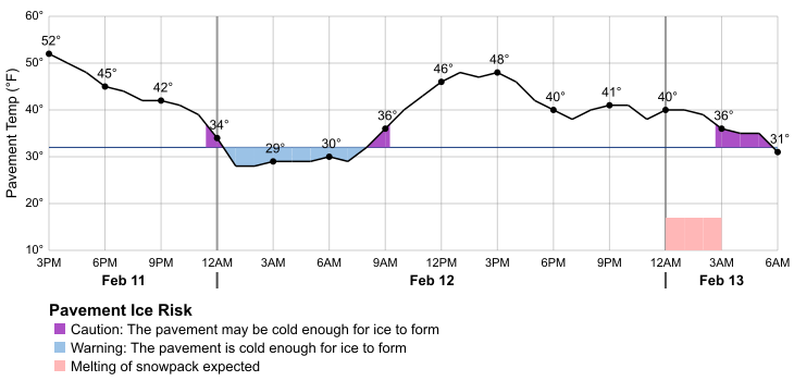
Pavement Risk Information
|
|
|
|
|
|
Minimum 3hr
Pavement Temp
|
Snow Melt
|
Weather
|
|
Feb 11
|
3 PM - 6 PM
|
48
|
No
|
Clouds give way to breaks of sun.
|
|
Feb 11
|
6 PM - 9 PM
|
42
|
No
|
Partly cloudy.
|
|
Feb 11
|
9 PM - 12 AM
|
39
|
No
|
|
Feb 12
|
12 AM - 3 AM
|
28
|
No
|
|
Feb 12
|
3 AM - 6 AM
|
29
|
No
|
|
Feb 12
|
6 AM - 9 AM
|
29
|
No
|
Filtered AM sun fades into thickening clouds late.
|
|
Feb 12
|
9 AM - 12 PM
|
36
|
No
|
|
Feb 12
|
12 PM - 3 PM
|
46
|
No
|
|
Feb 12
|
3 PM - 6 PM
|
42
|
No
|
|
Feb 12
|
6 PM - 9 PM
|
38
|
No
|
Overcast. Light precip, mostly as rain, develops after 9 PM. The rain mixes more with snow/sleet as it turns steadier around midnight, becoming sleet then mostly snow 2 - 5 AM.
|
|
Feb 12
|
9 PM - 12 AM
|
38
|
No
|
|
Feb 13
|
12 AM - 3 AM
|
39
|
Yes
|
|
Feb 13
|
3 AM - 6 AM
|
35
|
Yes
|
|